|
Download Members: $0.00 Non‑Members: $75.00 |
Buy Now |
Publication Details
| Published Date: | |
|---|---|
| Authors: | Jacob Michael Hubert, Robert Walter Murray |
| Download Format: |
Abstract
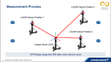
Large volume 3D scanners often rely on constellations of alignment fiducials as means to register and align several scan point clouds together, whether pre-defined with an external device or defined in-situ. The premise of our research is to quantify the uncertainty and performance characteristics of defining point cloud alignments by measuring the sensor position with an external device in global coordinates. This could lead to cost and time savings in multiple ways such as reductions in foreign object debris (FOD) introduced by targets used in full aircraft scan scenarios, reduction in re-alignment and setup time, etc. This presentation will discuss our approaches and quantify the results and found limitations surrounding the method of defining global sensor location as a means of aligning point clouds and scans.


